Difference between revisions of "Wind profile"
(→Process) |
(→FlySafe database for the wind profile data from the KNMI Doppler radar) |
||
| (3 intermediate revisions by the same user not shown) | |||
| Line 1: | Line 1: | ||
| − | = | + | = FlySafe database for the wind profile data from the KNMI Doppler radar = |
| − | |||
| − | |||
| − | |||
| − | |||
| − | |||
===References=== | ===References=== | ||
| Line 10: | Line 5: | ||
KNMI description for HDF5 V 3.5: | KNMI description for HDF5 V 3.5: | ||
| − | [http://www.knmi.nl/kodac/over_kodac/catalogus/hdftag3-5.pdf | + | [http://www.knmi.nl/kodac/over_kodac/catalogus/hdftag3-5.pdf http://www.knmi.nl/kodac/over_kodac/catalogus/hdftag3-5.pdf] |
KNMI description of data product: | KNMI description of data product: | ||
| − | [http://www.knmi.nl/kodac/over_kodac/catalogus/nl-rdr-data-wind-prof-5m.htm | + | [http://www.knmi.nl/kodac/over_kodac/catalogus/nl-rdr-data-wind-prof-5m.htm http://www.knmi.nl/kodac/over_kodac/catalogus/nl-rdr-data-wind-prof-5m.htm] |
| − | |||
==Process== | ==Process== | ||
| Line 25: | Line 19: | ||
==Datamodel== | ==Datamodel== | ||
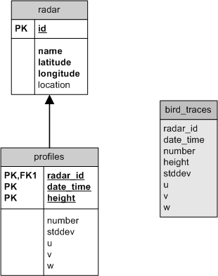
| − | [[Image | + | [[Image:Windprof_datamodel.png]] |
The datamodel for the wind profile data is very simple. The '''radar '''table gives the name , the latitude and longitude of the radar. The location is the GIS representation for latitude/longitude. | The datamodel for the wind profile data is very simple. The '''radar '''table gives the name , the latitude and longitude of the radar. The location is the GIS representation for latitude/longitude. | ||
Latest revision as of 11:46, 14 May 2008
Contents
FlySafe database for the wind profile data from the KNMI Doppler radar
References
KNMI description for HDF5 V 3.5:
http://www.knmi.nl/kodac/over_kodac/catalogus/hdftag3-5.pdf
KNMI description of data product:
http://www.knmi.nl/kodac/over_kodac/catalogus/nl-rdr-data-wind-prof-5m.htm
Process
The wind profile data is being retrieved from the KNMI website twice a day and imported into the database. Wind profiles are produced every 5 minutes for two locations, De Bilt and Den Helder. If there are not sufficient radar reflections these profiles are not or only partly available. The schema used for the wind profile data tables and views is WINDPROF.
Datamodel
The datamodel for the wind profile data is very simple. The radar table gives the name , the latitude and longitude of the radar. The location is the GIS representation for latitude/longitude.
The profiles table stores all the wind profiles. The radar_id is a reference to the radar. The date_time is a timestamp which gives the date and time of the wind profile data. The height gives the geometric height in meters of the profile. The u,v and w values are east-west, north-south and vertical components of the wind-speed in m/s. The stddev value is standard deviation of radial velocity. This value is used to determine whether birds are present because the variability of the radial velocity can be caused by birds. If this value is bigger then 2.0 then probably birds are present.
The bird_traces view selects from the profiles table all records where the stddev value is bigger then 2.0.
